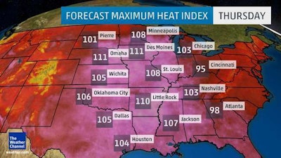
 The heat index forecast for Thursday.
Photo: The Weather Channel
We are well into the dog days of summer, but a rather intense heat wave is expected to spread from the central United States to the mid-Atlantic and Northeast by the weekend.
This heat dome will reach from Canada to the Gulf Coast on Thursday. A majority of the central states can expect heat indices – a combination of temperature and humidity – to range from 100 to 115 degrees.
On Wednesday, more than 42 million people were under a heat alert from Minneapolis all the way to Shreveport, Louisiana.
The Southeast can expect temperatures from the mid-90s to near 100 degrees, with Nashville predicted to see its first triple-digit reading since July 2012.
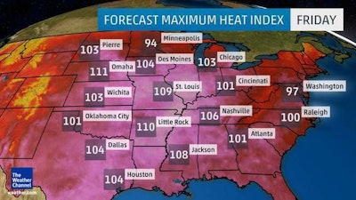
By the weekend, even the Northeast will be sweltering, with temperatures in the upper 90s. The same goes for Washington D.C., Philadelphia and New York City.
The National Weather Service currently has 16 states under one or more of the different heat warnings. Heat Advisories are issued when the heat index value is expected to reach 105-109 degrees within the next 12 to 24 hours.
Excessive Heat Watch is issued when the heat index value could reach or exceed 110 degrees within 24 to 48 hours. Excessive Heat Warnings are for when the heat index value is expected to reach or exceed 110 degrees within the next 12 to 24 hours.
 The heat index forecast for Friday.
Photo: The Weather Channel
The humidity coupled with the high temperatures are the reason why heat indices will climb so high later in the week. Overnight lows will only reach the mid-70s, causing the sultry weather to linger on longer than anyone would like.
Beneath the high-pressure dome, air will sink and warm, causing thunderstorms to be sporadic, leaving most areas dry.
With these dangerous temperatures on the way, be sure to monitor your crews to prevent heat-related illnesses.
Workers should stay hydrated and take breaks in the shade as often as possible. Click the link for more tips on heat safety.


